Escalante & Bryce Canyon
Hello!
We left Capitol Reef on Wednesday and moved to Panguitch, UT - near Bryce Canyon NP. On the way we traveled on UT12, a scenic highway. This road was amazing, the scenery was varied, the road was super cool - if you ever get a chance to travel this way - enjoy the views - but watch out for the cows!
This road takes you through Dixie National Forest and Escalante - Grand Staircase National Monument. We chose to do a hike called "Zebra Canyon". The reviews on All Trails were pretty good - we did decide ahead that we were not going to go for a swim to get to the end of the canyon. We figured we would see what it was like and get some pictures.
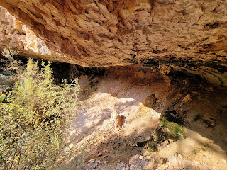
It was a long hot hike to get to the slot canyon. Along the way there were some cool rock formations:
Dried mud in the "wash". It was super crunchy to walk on.... Kind of a warning of what can happen to you if you run out of water.We hiked back to the car, which was like 1000 miles away. At the end of the day we had over 18,000 steps - most of it in the HOT SUN.
Our place in Panguitch is nice. It is a studio apartment in a converted garage. Sounds kinda sketch but it is brand new!
On Thursday we woke to a very cold morning. We had breakfast, made our lunch and headed to Bryce Canyon (about 30 minutes away). When we got to the trail head it was 32 degrees (at 8 am). We actually waited in the car for it to warm up a bit before we started, since we were wearing shorts in anticipation of a warm afternoon.... Brrrr!
Our hike was Queen's Garden + Navajo Loop. Bryce Canyon is the home of the Hoodoos. It was beautiful and strange:
When we finished this 2.9 miles hike it was 68 degrees (90 minutes later). That's nuts!
We jumped in the car and headed to the end of the scenic road in BCNP - Rainbow Point elevation 9,115 for a short walk and lunch. More hoodoos:
Natural Bridge (misnamed because it is actually an arch) was a pretty stop as well:
Waterfall & Carsten -


Comments
Post a Comment